


 167 / 252

165
britannica - americana
LA PÉROUSE JEAN FRANÇOIS DE GALAUP DE
(1741-1788).
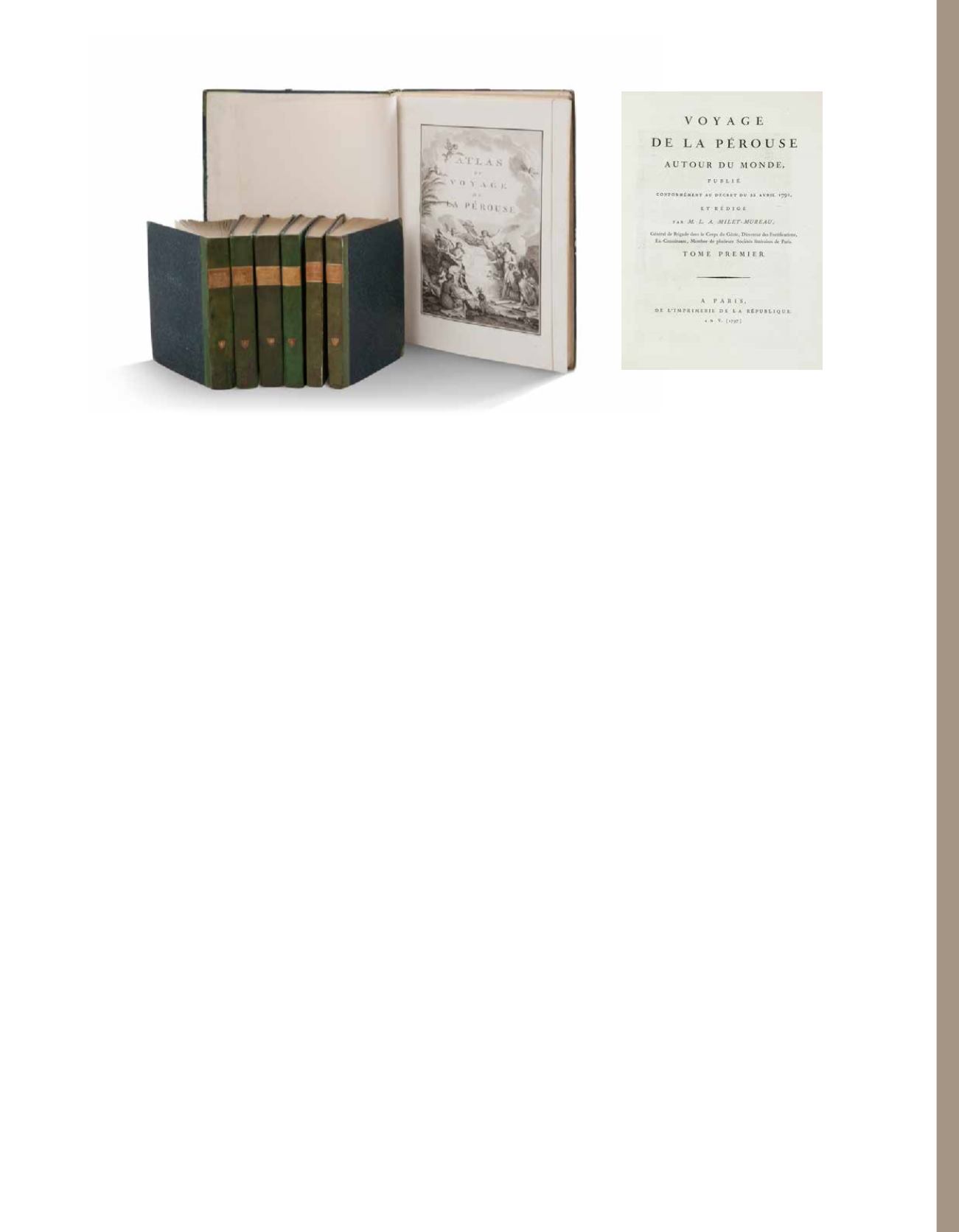
Voyage de La Pérouse autour du monde, publié
conformément au décret du 22 avril 1791, et rédigé par
M. L. A. Milet-Mureau
Paris, Imprimerie de la République, An V [1797].
5 000 / 6 000 €
4 text volumes, in-4 format, [4], lxxii, 346, [1]; [4], 398, [1] ; [4], 422, [1] ; [4],
309 pages, engraved portrait of La Pérouse after Tardieu ; 1 in-folio
atlas, with engraved allegorical title-page by Moreau le Jeune, titled
“Atlas du voyage de La Pérouse”, 69 engraved plates comprising folding
world map, 38 views and natural history plates, 30 maps or coastal
profiles (of which 20 double-page; 10 full page maps) by Le Pagelet,
Thomas, Godefroy, Choffard, Avril, Legrand et d’autres d’après Duché
de Vancy, Blondela, Prévost, La Martinière, etc., text volumes on blue
paper. Bound in green-stained half-vellum, title-pieces in yellow
morocco, yellow edges. Dimensions of text volumes: 215 x 280 mm;
dimensions of atlas volume: 375 x 528 mm.
First edition of one of the most important scientific explorations
ever undertaken to the Pacific and the northwest American coast,
and the first scientific voyage to California.
In 1783 the French government resolved to send an expedition to the
Pacific to complete Captain James Cook’s «unfinished work, and in
particular to explore the passages in the Bering Sea, which had been
a mystery to Europeans since the sixteenth century. King Louis XVI
himself took a hand in drafting the plan and itinerary and when La
Pérouse was selected to lead the fleet gave him an audience before
he sailed. In command of two ships, La Boussole and L’Astrolabe
(Commandant de Langle), he left Brest on 1 August 1785 making
for Brazil. Doubling Cape Horn he refitted in Chile, then sailed to
the Sandwich Islands and thence to Alaska, where he turned south
exploring and surveying the coast as far as California. After a short
refit at Monterey, he sailed across the Pacific, discovered uncharted
islands, and visited Macao and Manila. After six weeks he left on 10
April 1787 to survey the coasts and territories north of Korea, which
had been described and commented on by Christian missionaries.
He sailed up the Gulf of Tartary, naming several points on both its
shores and learned that Sakhalin was an island.
In September he put in to Kamchatka to replenish his supplies. From
there he dispatched an officer, Lesseps, overland to Paris with accounts
of his discoveries, while he turned south making for New Holland:
these accounts served to establish the present work and illustrations.
In December, at Tutuila, Samoa, which Bougainville had called the
Navigator Islands when he explored them in 1768, natives suddenly
attacked a party from L’Astrolabe seeking water and killed de Langle
and eleven others. La Pérouse left without taking reprisals and sailed
through the Pacific Islands to Norfolk Island and to Botany Bay. He
was sighted off the coast there on 24 January 1788 but bad weather
prevented his entering the bay for two days. By then Governor Arthur
Phillip had sailed to Port Jackson, but John Hunter had remained
with the Sirius and the transports, and assisted La Pérouse to anchor.
He established a camp on the northern shore, now called after him,
and maintained good relations with the English during his six-week
stay. He sailed on 10 March and was not heard of again.
Hill 972; Forbes 272; Ferguson 251; Sabin 38960.
Sold with :
LABILLARDIÈRE, JACQUES-JULIEN DE
(1755-1834).
Relation du voyage à la recherche de La Pérouse,
fait par ordre de l’Assemblée Constituante, pendant
les années 1791, 1792 et pendant la 1ère et la 2
ème
année
de la République Françoise.
Paris, Jansen, 1800.
And
Atlas pour servir à la Relation du voyage à la recherche
de La Pérouse fait par ordre de l’Assemblée constituante,
pendant les années 1791, 1792 et pendant la 1ère et 2ème
année de la République française.
A Paris, Chez F. Schoell, 1811.
First edition.
2 volumes in-4, XVI, 442 pp.; 332 pp., 113 pp. (Malay and New Caledonia
vocabulary), (1) p. errata ; 1 Atlas in-folio with 44 plates (after Piron,
Redouté and the author), including 1 folding-out map. Bound in green-
stained half-vellum, title-pieces in yellow morocco, yellow edges
(some foxing to test volume; some creases to plate but generally in
fresh crisp condition). Dimensions of text volumes: 215 x 278 mm;
dimensions of atlas volume: 375 x 528 mm.
NOTA BENE: The Labillardière Atlas is bound in a single folio volume
in conjunction with the La Pérouse Atlas. Homogeneous period
bindings for this ensemble (including the atlases). Marginal tear to
plate 40 in the La Pérouse Atlas. Hinges fragile in all text volumes
(La Pérouse et La Billardière).