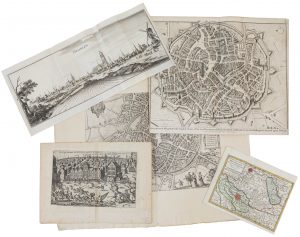
(MALINES) — Un lot varié de topographie de la fin du XVIe siècle jusqu'au milieu du XVIIIe siècle: – 1. Un plan gravé provenant de Giucciardini, titré 'Nitidissimae civitatis Mechliensis', vers 1582. Collé sur support. 335 x 450 mm – 2....
Description
■ (MECHELIN) — A varied lot of late–16th til mid–18th century topography:
1. An engraved plan from Giucciardini, titled ''Nitidissimae civitatis Mechliensis', ca. 1582. Attached to support. 335 x 450 mm
2. An engraved view of the scuffle during the Eighty Years' War, by Frans Hogenberg, published in Aitzinger, ca. 1596–1606. 185 x 285 mm
3. An engraved panoramic view by Matthias Merian from 'Topographia Germaniae Inferioris', Frankfurt, 1659. 135 x 510 mm
4. An engraved plan from 'Maps and plans from the history of England by Mr. Rapin de Thoyras', published in London, 1744. 390 x 470 mm
5. A partially coloured map, titled 'De Heerlykheid Mechelen. Nevens haar onderhoorige Gebieden. Volgens de Nieuwste Waarneminge', published in Elwe's atlas, 1786. 180 x 240 mm
Tot. : 5
DESCRIPTION NL.
■ (MECHELEN) — Een gevarieerd lot laat 16de tot midden 18de–eeuwse topografie:
1. Een gegraveerde plattegrond uit Guicciardini, getiteld 'Nitidissimae civitatis Mechliniensis', ca 1582. Geplakt op drager. 335 x 450 mm
2. Een gegraveerd gezicht van de schermutselingen tijdens de 80–jarige oorlog, door Frans Hogenberg, uitgegeven in Aitzinger, ca. 1596–1606. 185 x 285 mm
3. Een gegraveerd panoramisch gezicht door Matthias Merian uit 'Topographia Germaniae Inferioris', Frankfurt, 1659. 135 x 510 mm
4. Een gegraveerde plattegrond uit 'Maps and plans from the history of England by Mr. Rapin de Thoyras', uitgegeven in London, 1744. 390 x 470 mm
5. Een deels gekleurd kaartje, getiteld 'De Heerlykheid Mechelen. Nevens haar onderhoorige Gebieden. Volgens de Nieuwste Waarneminge', uitgegeven in Elwe's atlas, 1786. 180 x 240 mm
Tot. : 5 ex.


