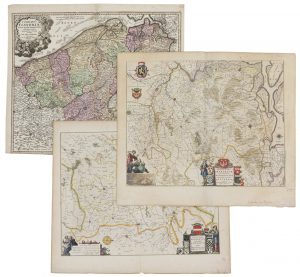
(FLANDRE–BRABANT) — Un lot varié de topographie: – Une carte gravée et coloriée du Comté de Flandre du début du XVIIIe siècle par Homann, titrée 'Comitatus Flandriae', 1716. 480 x 570 mm – Deux cartes partiellement coloriées du Duché...
Description
■ (FLANDERS–BRABANT) — A varied lot of topography:
– An early 18th century engraved and coloured map of the County of Flanders by Homann, titled 'Comitatus Flandriae', 1716. 480 x 570 mm
– A pair of 17th century partially coloured maps of the Duchy of Brabant and the Marquisate of Antwerp by Flor A Langren, published in Blaeu's 'Grooten Atlas', titled 'Prima – Tertia pars Brabantiae', ca. 1640. Decorated with coat of arms, legend and title cartouche. 415 x 520 mm (x 2)
Tot. : 3 ex.
DESCRIPTION NL.
■ (VLAANDEREN–BRABANT) — Een gevarieerd lot topografie:
– Een vroeg 18de–eeuwse gegraveerde en ingekleurde kaart van het graafschap Vlaanderen door Homann, getiteld 'Comitatus Flandriae', 1716. 480 x 570 mm
– Een paar 17de–eeuwse en deels ingekleurde kaarten van het hertogdom Brabant en het markiezaat Antwerpen door Flor A Langren, uitgegeven in Blaeu's 'Grooten Atlas', getiteld 'Prima – Tertia pars Brabantiae', ca. 1640. Versierd met wapen, legende en titelcartouche.
415 x 520 mm (x 2)
Tot. : 3 ex.


