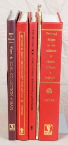
(CARTOGRAPHIE). CHUBB (Thomas). The Printed Maps in the Atlases of Great Britain and Ireland. A Bibliography, 1579-1870. Londres, 1927 (Réimpression, 2004).
Description
Nombreuses reproductions hors texte.
▬ On joint :
• WINSOR (Justin). The Kohl collection (now in the library of Congress) of maps relating to America. With index by Philip Lee Phillips. Washington, 1904 (Réimpression, 2002). In-8, (1) f + 189 pp. toile de l'éditeur. "In all 474 early maps of American are described, many with useful annotations and comments".
• FORDHAM (Herbert George). Studies in Carto-Bibliography British and French and the bibliography of itineraries and Road-Books. Oxford, Clarendon Press, 1914 (Réimpression, 2004). In-8, (1) f + VII pp. + (1) f + 180 pp. toile rouge éditeur.
• FORDHAM (Herbert George). Studies in Carto-Bibliography British and French and the bibliography of itineraries and Road-Books. Oxford, Clarendon Press, 1914 (Réimpression, 2004). In-8, (1) f + VII pp. + (1) f + 180 pp. toile rouge de l'éditeur. 4 illustrations dont le frontispice et une planche hors texte.
• Et 2 plaquettes : The La Rochefoucauld Atlas vendu aux enchères en 1994.
• MARCEL (Gabriel). Les origines de la carte d'Espagne. Paris, 1899.


