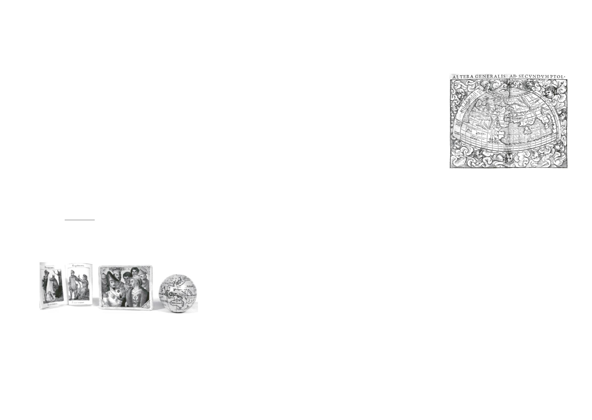

166 – (Mappemonde) -
MUNSTER, Sébastien.- Altera generalis ab secundum
Ptol[emaeum].
[Basel, 1550-1572].
Gravure sur bois, TC 25,5 x 34 cm + marges (pli central).
Est.
:
500/ 600 €
Mappemonde d'après Ptolémée figurant
l'Europe, l'Afrique (jusqu'à l'Ethiopie)
et l'Asie (jusqu'à et y compris le sous-
continent indien). La "Terra incognita"
de la cosmographie médiévale est
remplacée par "Terra cognita secundum
Ptolemeum", indiquant que l'hémisphère
sud était connue par Ptolémée. Extraite
d'une édition latine de la "Cosmographia"
comprenant aussi une mappemonde
"moderne". Intéressant et très décoratif.
# Shirley 76; # Ruland, A survey of the
double-page maps, in Imago Mundi 1962,
p. 84-97; # ETH-BIB (Zürich)/Rar9162.
Ptolemy's woodcut world map published by Sebastian Münster.
167 – (Mappemonde) -
WALDSEEMÜLLER, Martin.- Universalis cosmographia
secundum olomaei [...].
[Strassbourg, 1507].
Facsimile, woven paper, 70,5 x 123,5 cm (visible), hand colored details.
Under glass and gilt frame.
Est.
:
800/ 1.000 €
High quality facsimile of the unique copy of Waldseemüller's large 1507 world map, now held
at the Library of Congress. This first map to show the name "America" (applied to Brazil)
is mainly drawn on a modification of Ptolemy's conical projection. Waldseemüller used
Ptolemy as a source for most of Europe and Asia, while Africa was based on Portuguese
travels and some of the other regions on manuscript charts. While Ptolemy flanks the east
hemisphere at the head of the map, Amerigo Vespucci is at the western one, because
-according the lower left-hand corner legend-, the representation of the new world is based
on Vespucci's four voyages. Waldseemüller's wall map was recognized as an outstanding
cartographical masterpiece and as a consequence his contemporaries relied heavily upon
it. The present facsimile is probably published by Schuler Verlag of Stuttgart.
# Shirley 26.
168 – (Monde) -
MALTE-BRUN, Conrad.- Géographie universelle. Revue,
rectifiée et complètement mise au niveau de l'état actuel des connaissances
géographiques par E. Cortambert.
Paris, Boulanger et Legrand, 1863 [- 1864].
8 vol. in-8°; 1 front., plusieurs h.-t. et cartes, qqs-unes dépl. aux contours rehaussés (qqs pp. lég. brunies,
piqûres, rouss., pâles mouill. marg., cartes brunies, déch. marg. à 2 cartes dont 1 restaurée, rares pp. part.
déreliées).
Rel. de l'époque : demi-chagrin brun, plats de papier marbré, dos à nerfs, tr. jaspées de brun (cuir frotté, pet.
us., pet. manques de papier, coupes et coins lég. émoussés).
Est.
:
100/ 120 €
Cartographie
Cartografie
163 – (Atlas, Monde) -
Atlas composite renfermant 106 cartes du 17
e
et 18
e
siècles.
In-f° : 106 gravures sur cuivre à double pages, montées sur onglets, rehaussées à l'aquarelle et num. à la plume
(bords des prem. cartes effrangés, 1
er
cahier dérelié, qqs faibles taches, qqs déchir. sans manque renforcées).
Rel. de l'époque : plein veau (ex-libris armoriés gravés au contreplat, fortes us., gardes déchirées).
Est.
:
5.000/ 6.000 €
Comprend : la mappemonde et les 4 continents par De Wit, 1 carte de l'Europe par Visscher
et Schenck, 98 cartes concernant l' Europe par De Wit (18), Allard (1), Janssonius (49),
Blaeu (8), Mercator (1), Visscher (7), Sanson (6), Hondius (2), Le Rouge (1), De l'Isle (3),
Covens et Mortier (1), Ottens (1) et 2 plans de ville (Stockholm et Saint-Petersbourg).
▲ Provenance : Florentius Coupplet, "pastor in Keerberghen".
Assembled atlas composed of 106 maps : 1 world map and 4 maps of the continents by De Wit,
1 map of Europe by Visscher and Schenck, 98 European maps and 2 city plans. All on double pages
and coloured (1st quire unbound, margins of 1st lvs worn, some spotting and restored small tears).
Contemporary full calf (binding used, tears in upper Joint and in lower headband).
164 – (Globe) -
[BAUER, Carl Johann Sigmund].- Die Erde im kleinen C.B.
[Nuremberg, 1800-1825].
Globe : copper engraving, diameter 4 cm, colored; booklet of 28 engraved plates vowed in accordion,
4,5 x 5,5 cm, colored, pasted to the bottom of the box.
In original pink card box (5,5 x 6,5 x 6 cm).
Est.
:
800/ 1.000 €
Charming Victorian terrestrial globe
made up of 12 hand coloured engraved paper
gores. With booklet of 28 plates showing people of all nations in traditional costumes, each
labeled in English and German. Illustrated label on the lid of the box. Though it differs from
the one recorded by Van der Krogt, it holds the same maker's initials "C.B." and should be
as such a rare version of the globes the Bauer family produced as a gadget for the market.
Vancouver 's discoveries at the end of the 18
th
century are recorded at the northwest coast
of America. Handwritten notes on the bottom of the box.
# Van der Krogt BAU 1.
Sphère terrestre miniature composée de 12 fuseaux sur cuivre et rehaussés. Avec livret en forme
d'accordéon comportant 28 illustrations figurant les peuples du monde, gravées et rehaussées. Le tout
dans sa boîte d'origine de carton couvert de papier gaufré rose.
165 – (Mappemonde) -
MERCATOR, Rumold.- Orbis terra compendiosa descriptio.
1587.
Copper engraving, TC 28,7 x 52 cm + margins, colored (vertical fold, small tears on the edges, browned, paper
strokes pasted on the verso).
Est.
:
1.200/ 1.500 €
Mercator’s great world map
of 1569 condensed into a double hemispherical form by his
son Rumoldus. The map was published in the french edition of Mercator 's atlas in 1609 and
in 1619.
# van der Krogt [0001:1A]; # Shirley 157.
Mappemonde en deux hémisphères par Mercator donnée par son fils Rumold (1587). Extraite de
l'édition française de l'atlas publié par Jodocus Hondius en 1609 et en 1619.


